
Lêer:Austrian Empire (1815).svg

Size of this PNG preview of this SVG file: 450 × 456 piksels. Ander resolusies: 237 × 240 piksels | 474 × 480 piksels | 758 × 768 piksels | 1 011 × 1 024 piksels | 2 021 × 2 048 piksels.
Oorspronklike lêer (SVG-lêer, normaalweg 450 × 456 piksels, lêergrootte: 691 KG)
Opsomming


.svg)
.svg)
.svg)
.svg)
.svg)


.svg)
.svg)
.svg)


.png)
.png)


.svg)


.svg)

.svg)


.svg)
.svg)
.svg)
.svg)


.svg)
.png)


.svg)


.svg)
.svg)


.svg)


.svg)


.svg)
.svg)
.svg)
.svg)
.svg)
.svg)
.svg)
.svg)
_cropped.svg)
.svg)
.svg)
.svg)
.svg)
.svg)
.svg)
.svg)
.svg)
.svg)
.svg)
.svg)
.svg)
.svg)
.svg)
.svg)
.svg)
.svg)
.svg)
.svg)
.svg)
.svg)
.svg)
.svg)
.svg)
.svg)
.svg)
.svg)
.svg)
.svg)
.svg)
.svg)
.svg)
.svg)
.svg)
.svg)
.svg)
.svg)
.svg)
.svg)
.svg)
.svg)
.svg)
.svg)
.svg)
.svg)
Lêergeskiedenis
Klik op die datum/tyd om te sien hoe die lêer destyds gelyk het.
| Datum/Tyd | Duimnael | Dimensies | Gebruiker | Opmerking | |
|---|---|---|---|---|---|
| huidig | 09:58, 16 April 2019 | | 450 × 456 (691 KG) | TRAJAN 117 | +++ |
| 21:20, 12 Augustus 2013 |  | 450 × 456 (654 KG) | TRAJAN 117 | Update | |
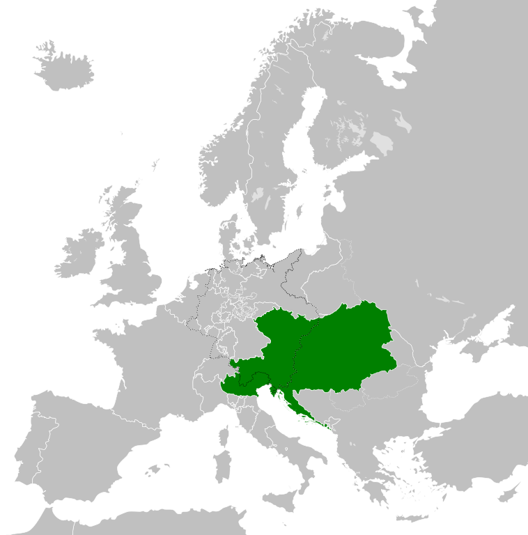
| 05:47, 12 Augustus 2013 |  | 450 × 456 (1 MG) | TRAJAN 117 | {{Information |Description ={{en|1=The Austrian Empire in 1815.}} |Source ={{own}} {{AttribSVG|Blank map of Europe 1815.svg|Alphathon}} |Author =TRAJAN 117 {{created with Inkscape}} |Date =2013-08-12 |Pe... |
Lêergebruik
Die volgende bladsy gebruik dié lêer:
Globale lêergebruik
Die volgende ander wiki's gebruik hierdie lêer:
- Gebruik in ast.wikipedia.org
- Gebruik in azb.wikipedia.org
- Gebruik in ba.wikipedia.org
- Gebruik in bg.wikipedia.org
- Gebruik in br.wikipedia.org
- Gebruik in ce.wikipedia.org
- Gebruik in cs.wikipedia.org
- Gebruik in cy.wikipedia.org
- Gebruik in de.wikipedia.org
- Gebruik in el.wikipedia.org
- Gebruik in en.wikipedia.org
- Gebruik in es.wikipedia.org
- Gebruik in fi.wikipedia.org
- Gebruik in frr.wikipedia.org
- Gebruik in fr.wikipedia.org
- Gebruik in ga.wikipedia.org
- Gebruik in gd.wikipedia.org
- Gebruik in gl.wikipedia.org
- Gebruik in he.wikipedia.org
- Gebruik in hi.wikipedia.org
- Gebruik in hr.wikipedia.org
- Gebruik in hy.wikipedia.org
- Gebruik in id.wikipedia.org
- Gebruik in id.wikibooks.org
- Gebruik in incubator.wikimedia.org
- Gebruik in is.wikipedia.org
- Gebruik in it.wikipedia.org
- Gebruik in jam.wikipedia.org
- Gebruik in ja.wikipedia.org
- Gebruik in ka.wikipedia.org
- Gebruik in km.wikipedia.org
- Gebruik in ko.wikipedia.org
- Gebruik in ky.wikipedia.org
- Gebruik in lmo.wikipedia.org
- Gebruik in lt.wikipedia.org
- Gebruik in lv.wikipedia.org
- Gebruik in mk.wikipedia.org
- Gebruik in mn.wikipedia.org
- Gebruik in nap.wikipedia.org
- Gebruik in nl.wikipedia.org
- Gebruik in pa.wikipedia.org
Wys meer globale gebruik van die lêer.
.svg)
.svg)