
Lêer:Saint-Barthélemy Island topographic map-fr.svg

Size of this PNG preview of this SVG file: 800 × 533 piksels. Ander resolusies: 320 × 213 piksels | 640 × 427 piksels | 1 024 × 683 piksels | 1 280 × 853 piksels | 2 560 × 1 707 piksels | 5 208 × 3 472 piksels.
Oorspronklike lêer (SVG-lêer, normaalweg 5 208 × 3 472 piksels, lêergrootte: 6,7 MG)
Opsomming
| Beskrywing |
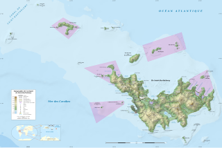
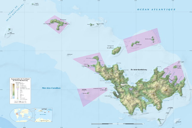
English: Topographic map in French of the Caribbean archipelago of Saint Barthélemy.
Note: the shaded relief is a raster image embedded in the SVG file. Français : Carte topographique en français de l'archipel de Saint-Barthélemy dans les Petites Antilles. Notes : le relief ombré est une image bitmap embarquée dans le fichier SVG.
|
||
| Datum | 2010-07, updated 2024-01 | ||
| Bron |
Eie werk
|
||
| Outeur | Eric Gaba (Sting - fr:Sting) | ||
| Toestemming (Hergebruik van die lêer) |
|
||
| Ander weergawes |
|


| Kameraligging | | Hierdie en ander beelde in: OpenStreetMap |
|---|

|
This SVG file contains embedded text that can be translated into your language, using any capable SVG editor, text editor or the SVG Translate tool. For more information see: About translating SVG files. |
Lisensiëring
Eric Gaba (Wikimedia Commons user Sting), die outeursreghouer van hierdie werk, publiseer dit onder die volgende lisensie:
This file is licensed under the Creative Commons Attribution-Share Alike 4.0 International license.
Naamsvermelding: Eric Gaba (Wikimedia Commons user Sting)
- U is vry:
- om te deel – die werk kopieer, versprei en deurgee
- om te hermeng – om die werk aan te pas
- Onder die volgende voorwaardes:
- naamsvermelding – U moet die nodige krediet gee, 'n skakel na die lisensie verskaf en aandui of daar veranderinge aangebring is. U mag dit op enige redelike manier doen, maar nie op enige manier wat daarop dui dat die lisensiegewer u of u gebruik onderskryf nie.
- insgelyks – As u die materiaal hermix, transformeer of voortbou, moet u u bydraes versprei onder die dieselfde of versoenbare lisensie as die oorspronklike.
Lêergeskiedenis
Klik op die datum/tyd om te sien hoe die lêer destyds gelyk het.
| Datum/Tyd | Duimnael | Dimensies | Gebruiker | Opmerking | |
|---|---|---|---|---|---|
| huidig | 01:55, 26 Januarie 2024 | | 5 208 × 3 472 (6,7 MG) | Sting | Completely new map using updated data; same geographic limits as previous version |
| 23:43, 17 Oktober 2015 |  | 2 430 × 1 620 (848 KG) | Sting | Using NASA SRTM 1 topographic data | |
| 19:00, 29 Julie 2010 |  | 2 430 × 1 620 (815 KG) | Sting | {== {{int:filedesc}} == {{Location|17|55|00|N|62|52|00|W|scale:50000}} <br/> {{Information |Description={{en|Topographic map in French of the Caribbean archipelago of Saint Barthélemy.<br/> ''Note: the shaded relief is a raster |
Lêergebruik
Die volgende bladsy gebruik dié lêer:
Globale lêergebruik
Die volgende ander wiki's gebruik hierdie lêer:
- Gebruik in ar.wikipedia.org
- Gebruik in ast.wikipedia.org
- Gebruik in bs.wikipedia.org
- Gebruik in de.wikipedia.org
- Gebruik in en.wikipedia.org
- Gebruik in eo.wikipedia.org
- Gebruik in es.wikipedia.org
- Gebruik in eu.wikipedia.org
- Gebruik in fa.wikipedia.org
- Gebruik in fr.wikipedia.org
- Gebruik in gl.wikipedia.org
- Gebruik in hu.wikipedia.org
- Gebruik in id.wikipedia.org
- Gebruik in incubator.wikimedia.org
- Gebruik in it.wikipedia.org
- Gebruik in kk.wikipedia.org
- Gebruik in lt.wikipedia.org
- Gebruik in nl.wikipedia.org
- Gebruik in pl.wikipedia.org
- Gebruik in ru.wikipedia.org
- Gebruik in sv.wikipedia.org
- Gebruik in ta.wikipedia.org
- Gebruik in th.wikipedia.org
- Gebruik in to.wikipedia.org
- Gebruik in uk.wikipedia.org
- Gebruik in ur.wikipedia.org
- Gebruik in uz.wikipedia.org
- Gebruik in vi.wikipedia.org
- Gebruik in www.wikidata.org